

The beloved road trip truly celebrates the journey itself, indulging in the miles upon miles it takes to get from one place to the next. While there are endless road trip options out there—themes include national parks, electric vehicle-friendly travel, and everything in between—the cross-country road trip arguably captures people’s imagination the most, with legendary roadways like Route 66 forming an integral part of the country’s history.
Many landscapes have changed over time, but the love of a small-town diner, quirky roadside attraction, and neon-lit motel is still firmly cemented in American culture. If you’re overdue for an adventure, here are seven cross-country road trips that will hopefully inspire a desire to see part of the United States you haven’t seen before.
1. Route 66
- Start: Chicago, Illinois
- End: Santa Monica, California
- Distance: 2,448 miles
“66 is the mother road, the road of flight,” John Steinbeck wrote in the Pulitzer Prize–winning The Grapes of Wrath. The road from Chicago to California is the most famous drive in the nation, even though it was technically removed from the U.S. Highway System in 1985. Drivers can still make this more than 2,000-mile drive (which celebrates its centennial in 2026) on their own, starting in Chicago and then hitting cities like St. Louis, Oklahoma City, and Santa Fe before finishing in Santa Monica. Along the way, the changing western landscape unfolds—from plains to desert to coast.
Route 66 has plenty of sights, from the artistic Cadillac Ranch in Amarillo, Texas, to downright breathtaking detours (Grand Canyon, anyone?) The drive is nearly 2,500 miles, so you can tailor it to your interest: One particular itinerary focuses on the American pastime of drinking whiskey, stopping at craft distilleries like Few Spirits in Chicago, Still 630 in St. Louis, and Red Fork Distillery in Tulsa.

Part of U.S. Route 2 runs through the Cascade Range in Washington.
Photo by Amehime/Shutterstock
2. U.S. Route 2
- Start: Houlton, Maine
- End: Everett, Washington
- Distance: 2,575 miles
Bring your passport or passport card for this one. This cross-country trip mostly parallels the northern border of the United States, with a brief section crossing through Canada in between Vermont and Michigan. Road-trippers start in Houlton, Maine and continue west on U.S. Route 2 until right before the Canadian border near Burlington, Vermont.
Going through Canada, travelers pass through Quebec and then Ontario via the Trans-Canada Highway. This section spotlights some of Canada’s Great Lakes scenery, including Pancake Bay Provincial Park’s beach and the 40-foot Kakabeka Falls in Thunder Bay. But cities like Montreal and Ottawa are also along the way, and warrant a weekend full of exploration in Canada’s historical and cultural hubs.
Once the route rejoins the USA in St. Ignace, Michigan—across from Mackinac Island State Park—there are still plenty of wild spots to see. The Apostle Islands National Lakeshore in Wisconsin and Montana’s Glacier National Park (reservations required) are a couple of highlights travelers hit before ending in Everett. This trip is best during the summer, when scenic places like the Great Lakes can be fully enjoyed.

Time Magazine featured U.S. Route 50 in a 1997 feature, calling it the “backbone of America.”
Photo by AJ9/Shutterstock
3. U.S. Highway 50
- Start: Ocean City, Maryland
- End: Sacramento, California
- Distance: 3,019 miles
When Time Magazine published a story about the U.S. Highway 50 in July 1997, it noted the road’s duality, saying, “The road gossips down Main Street and dresses up for the cities and, when it reaches the desert, stretches to the horizon and falls fast asleep.” From Ocean City, Maryland, it travels through cities like Washington, D.C. and Cincinnati before ending in West Sacramento.
But it’s the more sparsely populated parts of the country that have become associated with this particular road. Nevada’s section of U.S. Highway 50, sporting lone landmarks like a tree covered in shoes and mining towns like Eureka between miles of desert, was what Life Magazine called the “Loneliest Road in America” in the 1980s. While this drive is not for the fainthearted (there are only a few gas pumps between its endpoints in Ely and Fernley), it gives a sense of solace and quiet rarely found on the road nowadays.
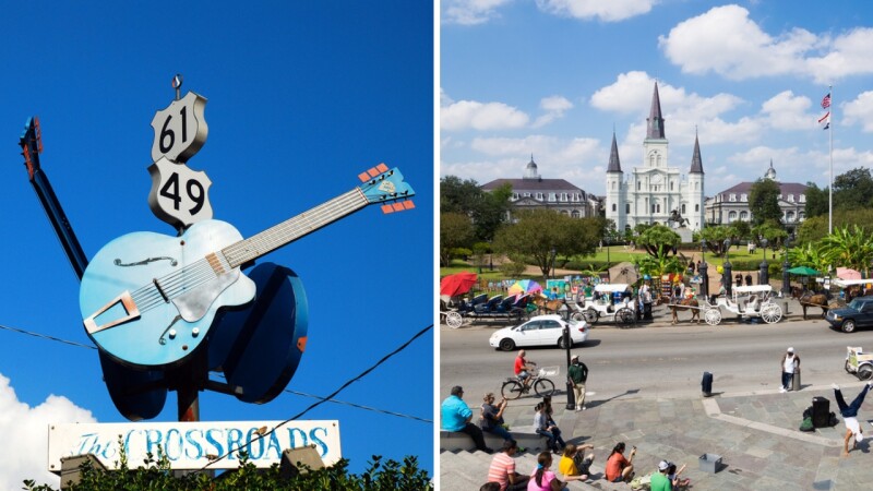
Reaching locations like Clarksdale, Mississippi and New Orleans, Louisiana, Route 61 is a road for music lovers.
Photos by James Kirkikis and IrinaK/Shutterstock
4. U.S. Highway 61
- Start: Wyoming, Minnesota
- End: New Orleans, Louisiana
- Distance: 1,407 miles
Bob Dylan wrote about his spiritual connection with U.S. Highway 61 in his memoir, stating that it “always felt like it was in my blood” as the road connected his birthplace in Duluth, Minnesota, through Mississippi Delta Country—the heart of the blues genre—to the music powerhouse city of New Orleans. (His love of the road has been immortalized in his 1965 album, Highway 61 Revisited.) While the highway now starts around 120 miles south in Wyoming, Minnesota, travelers on this road can still drive to New Orleans and find the birthplaces of artists who have been intrinsic to American music along the way: B.B. King, Johnny Cash, and Elvis Presley, to name a few.
It’s the blues genre that gave the road its nickname, the “Mississippi Blues Trail.” Explore this part of the road’s history by stopping at the Delta Blues Museum in Clarksdale and the Howlin’ Wolf Blues Museum in West Point. Much of Highway 61 is also a part of the Great River Road, a 3,000-mile series of state roads that parallel the full length of the Mississippi River. The road hugs the waterfront of river towns like Red Wing and Hastings in south Minnesota as well as natural areas like the Yazoo National Wildlife Refuge in Mississippi, offering scenic excursions to a journey rooted in the cultural history of the United States.

The Seven Mile Bridge in the Florida Keys is a part of U.S. Route 1.
Photo by Noah Densmore/Shutterstock
6. U.S. Route 1
- Start: Key West, Florida
- End: Fort Kent, Maine
- Distance: 2,369 miles
Not to be confused with Highway 1 in California, U.S. Route 1 passes through the East Coast from Florida to Maine. Starting from “Marker 0” in the Keys, the road travels along Florida’s coast before heading inland through Georgia, the Carolinas, Virginia, and New Jersey. But once drivers hit Connecticut, the road snakes by the coast again—and eventually by Maine’s side of the U.S.-Canadian border—before stopping in the small border town of Fort Kent.
The journey covers many of the East Coast’s biggest cities, including Miami, Washington, D.C., and Boston. But it also does a good job of sandwiching other landscapes—like the small towns of the Southeast—in between the grand coastal stretches and urban hubs. Of course, if there’s a part you want to skip, there’s always I-95, the interstate that parallels the U.S. Route 1 from Miami, Florida, to the Houlton–Woodstock Border Crossing in Maine.

Starting in Tybee Island, Georgia, U.S. Highway 80 travels more than 2,000 miles to its endpoint in San Diego, California.
Photos by zimmytws/Shutterstock and Chloe Arrojado
7. U.S. Highway 80
- Start: Tybee Island, Georgia
- End: San Diego, California
- Distance: 2,734 miles
When the Automobile Club of Savannah created the Dixie Overland Highway in 1914, it created the outline for what would become U.S. Route 80. The drive goes through both the Southeast and Southwest regions, connecting Tybee Island, Georgia, all the way to Southern California. The highway was wildly popular in the 1950s until different states started renaming parts of the road in the 1960s, turning pieces of the highway into different interstates.
Many portions of the highway are still considered important; states including Arizona have recognized parts of U.S. 80 as a historic route. The mostly forested, eastern portion until Dallas, Texas, is the largest portion still intact, occasionally going by Deep South cities like Macon, Georgia, and Montgomery, Alabama. Portions of the original road also exist west of Dallas, like New Mexico State Road 80 and Arizona State Route 80—but for the most part, drivers will need to follow a mix of I-8, I-10, and I-20 to recreate the path of U.S. 80. Nonetheless, the western half of the journey largely follows the red mesas and dry landscapes of the Southwestern region between cities like El Paso and Phoenix before ending in Southern California.


