

Get this: California has the most state parks in the country. Spread across the state are a whopping 279 parks, covering hundreds of thousands of acres. It’s a gold rush of parkland, which is both glorious and (sometimes) totally overwhelming. How to even begin? We’ve attempted to narrow down the list to a handful of our favorites, a mix of coastal retreats, redwood enclaves, and historic outposts.
There’s never been a better time to give a local park some love. For the first time ever, the state is hosting a California State Parks Week, June 14–18. Modeled after National Park Week, there will be days focused on land acknowledgement ceremonies and stewardship opportunities, among other things—check your favorite parks for a list of events.
If you plan to hit a lot of parks, download the California State Parks mobile app, which offers trail maps and GPS tracking, real-time updates about park conditions, and details about dog-friendliness and accessibility. (Don’t forget about the California State Park Pass, which offers a range of annual options like free passes for fourth-grade students and their families and the $195 annual pass.) For free vehicle access, California library card holders can check out park passes from their local library.
Here are 15 of our favorite state parks in California, all 15 selected by genuine Californians who love to spend time in nature.
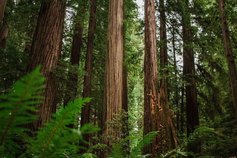
Jedediah Smith Redwoods State Park is home to the Grove of Titans, a sacred grouping of some of the world’s largest known redwoods.
Photo by Hannah Grace/Unsplash
1. Jedediah Smith Redwoods State Park
- Why go: Redwoods, redwoods, and more redwoods. And not many people!
- Nearest town: Crescent City, California
- Where to stay: Reserve one of the 106 sites at the park’s only campsite. Jedediah also offers four ADA-accessible cabins, which have heat and electricity but no bathrooms or kitchens. Crescent City, just five miles southwest, offers plenty of hotels and motels—consider the oceanfront Anchor Beach Inn.
As you cruise up California’s northern coast, you’ll pass a series of state parks that celebrate redwoods, all of which exist under the Redwoods National Park umbrella. Jedediah Smith Redwoods State Park is the last in the chain—it’s just a dozen miles south of the Oregon border, and five miles from the coast—and one of the least known. Yet it offers some of the densest of the redwood forests: The 10,000-acre park is home to 7 percent of the world’s old-growth redwoods, which can range from 500 to 2,000 years in age.
You could see them on a drive through the park’s narrow main artery, the Howland Hill Road, but why not get out and ogle them up close? Because Jedediah is so richly forested, there are only 20 miles of hiking trails.
The ones that exist highlight the park’s best features: Follow the 0.6-mile loop trail through Stout Grove, where redwoods as tall as 380 feet tower over you, and pass a variety of redwood groves (and a waterfall) on the 5.2-mile (round-trip) Boy Scout Tree Trail.
The Smith River, the state’s longest free-flowing river, cuts through the park and offers a playground for kayakers and fishers (salmon and trout both spawn here). Come summer, try a “redwood float.” Redwood Rides offers mellow, half- or full-day rafting tours that start north of the park and end with gentle rapids.

Come fall, scan for gold (leaves, that is) at Plumas-Eureka State Park, a former mining community.
Photo by Brian Baer
2. Plumas-Eureka State Park
- Why go: To nerd out about Gold Rush–era California
- Nearest town: Blairsden and Graeagle, California, are each about a 10-minute drive away.
- Where to stay: Upper Jamison is the park’s main campground with 60 sites, including four accessible sites. There are plenty of rentals and lodges around Blairsden and Graeagle, like the rustic-yet-elegant Chalet View Lodge.
Zoom back in time at Plumas-Eureka State Park in the Sierra Nevada and Cascade Range. Prospectors discovered gold here in 1851 and, over the course of nearly a century, more than $8 millions’ worth was mined from what was creatively known as Gold Mountain and is now called Eureka Peak. The mountain still contains about 65 miles of mining tunnels.
The only gold you’ll find here is on the trees come autumn, but you can still get into a Gold Rush state of mind. Tour the quaint brick-red museum, explore the mills, and during the annual “Gold Discovery Days” in July, watch a blacksmith make mining tools, pretend-pan for gold, and take a hay ride.
The Pacific Crest Trail (PCT) passes near the park, so it’s no surprise that the hiking in this part of the state is excellent, especially in summer. To stay in a Gold Rush state of mind, try the 3.5-mile Eureka Peak Loop Trail, which takes you up Eureka Peak for views of Eureka Lake. If you want to set foot on the PCT, take on the 3.7-mile (round-trip) Jamison Creek route, which connects to the famous, 2,650-mile West Coast trail.

Van Damme State Park showcases the best of Mendocino County.
Photo by Brian Baer
3. Van Damme State Park
- Why go: To explore a pygmy forest, kayak into sea caves, and hike through a fern canyon
- Nearest town: Little River, California
- Where to stay: Van Damme offers 68 sites, including 9 hike-in sites, in its only campground. There are dozens of cute inns and motels in Little River and Mendocino. We like Glendeven Inn & Lodge and the JD House.
Just three miles south of Mendocino, near the town of Little River, sprawls Van Damme State Park. This is coastal northern California at its best, 1,831 acres of redwoods and ferns, beaches and river fun, plus quirkiness in the form of a pygmy forest, where the trees are 100 years old—and all under 10 feet tall.
The park begins at the coast and stretches inland, encompassing Little River, which stretches to the Pacific. You could spend a day on the beach, or hike from the beach deep into the forest, following the river as you go. Other popular hikes include the 5.5-mile (round-trip) Fern Canyon Trail (no surprises in terms of scenery here). To extend the hike and see the Pygmy Forest, tack on the Old Logging Loop Trail, an additional 2.5 miles in total. (The forest is also visible from an accessible quarter-mile boardwalk in a different part of the park.)
Water folks: You can explore the park’s sea caves on a kayak—bring your own, or book a tour with Kayak Mendocino.

During the 1960s and 1970s, Petrov “Petro” Zailenko—aka the “Hendy Hermit"—lived in and near Hendy Woods State Park.
Photo by Brian Baer
4. Hendy Woods State Park
- Why go: To inhale the sweet scent of a redwood forest—then taste your way through the Anderson Valley wine region
- Nearest town: Philo, California
- Where to stay: Hendy Woods offers two forested campgrounds: the 43-site Azalea and the 49-site Wildcat. The park is a 7-minute drive from Philo and 12-minute drive from Boonville, both of which offer charming lodging, such as the Italianate Madrones, which has its own tasting rooms, and a sister party, the Brambles, with five cabins.
Hendy Woods State Park may be small—945 acres—but it packs a punch. Located three hours northwest of San Francisco in the Anderson Valley wine region, the park is a perfect place to stretch the legs between winery visits. Visit the two main groves that make up the park, Big Hendy and Little Hendy. Here, the trees reach as tall as 300 feet and some are believed to be 1,000 years old, dating back to the time the Pomo people occupied these lands.
Stroll the 1.6-mile Big Hendy loop trail, or the Hermit Hut Trail, which leads to a lean-to made of branches once believed to be occupied by the “Hendy Hermit,” a Russian veteran who called the park home.
The Navarro River cuts through part of the park. Take advantage of one of the picnic tables on the banks, or on warm days, cool off in the clear water.

From 1884 until 1959, Emerald Bay was home to the Emerald Bay Resort that capitalized on iconic Lake Tahoe views.
Photo by Brian Baer
5. Emerald Bay State Park
- Why go: Where else can you hike, tour a castle, and then scuba dive to view a watery ship grave?
- Nearest town: South Lake Tahoe, California
- Where to stay: The park’s 97-site Eagle Point Campground or the Emerald Bay Boat Camp, which true to its name, is only accessible by boat and offers 20 remote sites. And, of course, there are dozens upon dozens of cabins, hotels, Airbnbs, and more around Lake Tahoe (we like the Coachman Hotel).
Emerald Bay State Park just might offer, to quote Mark Twain, “the fairest picture the whole earth affords.” In more modern terms: It’s gobsmackingly gorgeous. Some 12 miles west of South Lake Tahoe, Emerald Bay is an arm of Lake Tahoe formed by a Pleistocene-era glacier, with a picturesque island, called Fannette, in the center.
The park is also, oddly, the home of Vikingsholm, a replica of a Scandinavian castle. In summer months, you can tour the castle to discover what led the original owner, Lora Josephine Knight, in 1928 to make her summer home an ode to Scandinavian architecture, down to the sod roofs and six fireplaces.
But nature is the real draw. Here, you can hike down to Emerald Bay Beach or tackle portions of the 22-mile Rubicon trail—the 8-mile round-trip hike to D.L. Bliss State Park is a popular option; kayak to Fannette Island; and snorkel or scuba to explore underwater wrecks. In 2018, the park rolled out the Maritime Heritage Underwater Trail, which highlights purposefully scuttled (sunk) watercraft at the bottom of the lake, including barges believed to have hauled materials for Vikingsholm.

Salt Point State Park is one of the few California parks where you can see the sandstone formations, known as “tafoni,” up close. They owe their unique Swiss cheese holes and honeycomb patterns to weather.
Photo by Brian Baer
6. Salt Point State Park
- Why go: To watch the Pacific pound the coastline, peer into teeming tide pools, and wonder over tafoni, the park’s honeycomb-like sandstone formations
- Nearest town: Jenner, California
- Where to stay: Within the park, there’s the ocean-side Gerstle Cove Campground (it gets windy!), or the forested Woodside Campground, east of Highway 1. Near Jenner, try the Timber Cove Resort.
Salt Point State Park, which extends east and west of Highway 1 in Sonoma County, is a geologically fascinating place. Named for the salt that crystallizes in the sandstone cliffs in the area, the park was once a critical resource for the native Kashaya Pomo people.
There are 6,000 acres to explore, including 20 miles of hiking trails. As you listen to the waves of the Pacific crash against the shoreline, you can hike the 3.8-mile loop trail to a pygmy forest or follow the trail to Fisk Mill Cove, where you might catch people diving for abalone.
Also part of the park is the Gerstle Cove State Marine Reserve—one of the state’s first underwater protected areas—where you can explore tide pools teeming with life: starfish, sea urchins, abalone, crabs, and so much more thrive here. Just watch where you step!

In its heyday, the gold-mining town of Bodie was home to some 6o saloons—and one church, a Methodist attempt at soul-saving built in 1882 that still stands today.
Photo by Brian Baer
7. Bodie State Historic Park
- Why go: It’s a shockingly well-preserved Gold Rush–era ghost town with, allegedly, a curse that haunts those who steal from it.
- Nearest town: Bridgeport, California
- Where to stay: There are no campgrounds in Bodie (would you stay even if there were??), but the town of Bridgeport has a handful of inns and motels. Ghosts not included. Many travelers stay in Mammoth Lakes, about two hours south, and make Bodie a day trip.
If you live and breathe ye old westerns, Bodie State Historic Park is practically alive with Wild West verve. In the late 19th century, more than 10,000 people lived here, most of whom were involved in the mining industry (gold, of course, was the big thing). In its heyday, Bodie was home to at least 60 saloons and a handful of gambling halls and opium dens. Unsurprisingly, it was known as a bit of a lawless place. The town fizzled out in 1932, following decades of dwindling mining activity and two serious fires.
But much of the town still remains, and it’s not hard to picture gunfights in the street or hear the squeak of tavern doors swinging as a new sheriff swaggered into town. Designated a historic site in 1962, Bodie still contains about 100 buildings, including a church, schoolhouse, and saloon, all filled with details from their day, now graced by tourists and—some say—the occasional ghost.
Park staff offer daily public tours and history talks, but for the real Bodie experience, book a tour or a ghost walk (eek) with the Bodie Foundation. Note that while restrooms are available, there are no services (so bring your own food and water).

The 115-foot-tall Pigeon Point lighthouse is listed on the National Register of Historic Places—and is a California Historical Landmark.
Photo by Brian Baer
8. Pigeon Point Light Station State Historic Park
- Why go: To visit—and bunk down near—one of the tallest lighthouses in the United States
- Nearest town: Pescadero, California
- Where to stay: On site! There’s a hostel in the park, though currently only the park’s three vacation rentals are available. Each has three bedrooms, two bathrooms, and a fully equipped kitchen.
Just off California’s historic Highway 1, 11 miles south of Pescadero, the 115-foot Pigeon Point Lighthouse has been safeguarding mariners along this foggy coast for 150 years. (It was built in 1872, following decades of shipwrecks, including the infamous Carrier Pigeon wreck.)
It’s not just historic decor: The lighthouse is still in use, although the Coast Guard uses an LED beacon instead of the original Fresnel lens. Currently, the lighthouse is undergoing restoration, but visitors can still tour the grounds—for a guided tour, make an appointment—and explore the marine areas that surround the lighthouse.
From the lighthouse grounds, visitors can follow steep steps down to the beach Whaler’s Cove, or tackle Mel’s Lane, a half-mile round-trip romp that offers excellent views. From November through April, these are prime places to park yourself with a picnic lunch and watch for migrating gray and humpback whales.

Over the years, Point Lobos has been the site of whaling, abalone harvesting, coal mining, and even secret military operations. Now it’s a protected natural reserve.
Photo by Brian Baer
9. Point Lobos State Natural Reserve
- Why go: To seek out rare plants, listen to the roar of sea lions, and dive deep beneath the Pacific
- Nearest town: Carmel-by-the-Sea, California
- Where to stay: There’s no campground here, but there are plenty of places to stay in Carmel-by-the-Sea and Carmel Valley—we recommend Carmel Valley Ranch and Bernardus Lodge & Spa.
Just 76 miles south of Pigeon Point, Point Lobos is considered one of the state’s crown jewels, in large part due to its 9,907-acre marine reserve–a diver’s paradise. Certified divers can swim through kelp forests, ooh and ahh over sea turtles and sea urchin, and explore a submarine canyon. (Not a diver? Via the park’s app, Dive Into Point Lobos, you can watch researchers as they explore the depths.)
There’s plenty to do on land, too. The park stretches from the waterfront and past Highway 1, offering more than a dozen trails, a cultural history museum, and bird-watching galore (more than 300 species pass through this park). The 0.8-mile round-trip Bird Island Trail is a (very) popular walk. It leads to Bird Island, where cormorants and gulls like to linger, and offers views of China Cove—one of the park’s most visited spots—as well as access to the Caribbean-esque Gibson Beach along the way.
If you want something a little less trafficked, try the North Shore Trail, a 3-mile (round-trip) hike between Whaler’s Cove and Sea Lion Point. Don’t miss the Whaler’s Cabin Museum, which houses whale bones, harpoons, and other fishing ephemera.

For more solitude than you’ll find in Point Lobos, head to Garrapata State Park, only five miles south.
Photo by Brian Baer
10. Garrapata State Park
- Why go: Wildflowers, redwood groves, and coastal hiking
- Nearest town: Carmel-by-the-Sea and Big Sur, California
- Where to stay: Carmel-by-the-Sea is a 15-minute drive away and Big Sur is 30 minutes away, so take your pick. In the more isolated Big Sur, try Ventana and Post Ranch Inn. The park doesn’t have a campground, but Pfeiffer Big Sur State Park is 3 minutes south by car and is one of the best places in Big Sur to camp.
Another iconic park along Highway 1, Garrapata is Big Sur beauty at its best. It’s much less populated than, say, Point Lobos, so hikers who like to commune quietly with nature, this is your place.
The nearly 3,000-acre park extends east from the coast toward the Santa Lucia Mountains. There are the rugged cliffs for which Big Sur is famous, a two-mile beach, and lots of excellent hiking trails. The 2.8-mile Soberanes Canyon Trail, for example, leads inland into the redwoods but offers sweeping views of the Big Sur coast.
In the spring and summer months, the park is lush with wildflowers, from poppies to wild irises. Look for the trail that leads to the “Calla Lily Valley,” where the wild elegant white flowers are known to bloom from January through April.

Tour Montaña de Oro’s iconic bluffs on the 3.4-mile round-trip Bluff Trail.
Photo by Brian Baer
11. Montaña de Oro State Park
- Why go: For sandy beaches, whale-watching, and a 4.4-mile hike up the 1,347-foot Valencia Peak
- Nearest town: Los Osos and Baywood, California
- Where to stay: Campers, check out the park’s main campground, Islay Creek, which has 48 sites. Prefer a bed to the ground? Check into the Inn at Morro Bay.
Continuing in the coastal vein, Montaña de Oro—located along California’s central coast—has 8,000 acres and 7 miles of coastline to explore.
Spooner’s Cove is the main beach, drawing beachcombers and kayakers (you can rent kayaks in nearby Morro Bay). Bonus: It’s also close to the park’s main campground, Islay Creek.
Hikers can follow their bliss on one of several trails, ranging from the gentle 3.4-mile Bluff Trail to the aptly named 11.2-mile Hazard Peak Trail, which delivers 1,000 feet of elevation gain. Wildlife lovers can peer down into the tidepools at Corralina Cove—a fine spot to see seals and sea otters—or watch for whales. The park is a prime spot along the Whale Trail: Humpback whales live here year-round while gray whales pass through from December to April.
Come spring, watch for the poppies that cover the hills. Montaña de Oro translates to “mountain of gold,” and in March and April, the hills don’t disappoint.

Red Rock Canyon State Park encompasses 27,000 acres of badlands that date back millions of years.
Photo by Brian Baer
12. Red Rock Canyon State Park
- Why go: To hike the badlands, examine the bones of prehistoric rhinos, and learn what a roadrunner really looks like.
- Nearest town: California City, California
- Where to stay: Ricardo Campground has 50 primitive campsites with pit toilets and potable water. (There are no RV hookups here, nor are there showers.) Four of the sites are ADA-accessible. Note that the campground isn’t reservable—it’s first come, first serve and spring and fall are the park’s busiest seasons. You’ll find simple motels in nearby California City (17 miles from the park) and Mojave, 25 miles away.
Not to be confused with Nevada’s Red Rock Canyon National Conservation Area, Red Rock Canyon State Park is like one large outdoor geological and anthropological museum. Some of the layers that make up the colorful canyons date back 65 million years.
It’s a small park, but a good stop on a trip to or from Death Valley or Sequoia National Park. While it’s one of the less-visited parks in California, it’s a popular film location. Aficionados may recognize Red Rock from such movies as Stagecoach and Jurassic Park.
Bring your dino-fiends to explore fossils and prehistoric bones on display at the visitor center, or tour the park’s rock formations along one of several trails. The mile-long Red Cliff Trail is among the most iconic, leading to a cliff view. Folks who want a longer hike and have good navigation skills can try the 8.8-mile Nightmare Gulch Loop, which opens to the public in June. (The trail isn’t well marked, so you’ll need to follow GPS instructions.)
It goes without saying, but pack your desert smarts: Avoid visiting at the height of summer and bring plenty of food and water. (There aren’t services in the park, though there is potable water.)

Crystal Cove State Park is one of the largest natural spaces in Orange County.
Photo by Brian Baer
13. Crystal Cove State Park
- Why go: To access rugged nature in one of the state’s busiest urban areas—and overnight in a classic seaside cottage
- Nearest town: Laguna Beach or Corona Del Mar, both about a five-minute drive away
- Where to stay: You can hike into one of three backcountry campsites, or book one of the 24 cottages in the park’s historic district. There are 10 dorm-style cottages and 14 stand-alone ones, ranging from studios to two bedrooms.
Just off the Pacific Coast Highway, Crystal Cove State Park is, to the outsider, a surprising stretch of open space in Orange County. It runs from the coast—where 3.2 miles of beach await—to El Morro, a 2,200-acre chaparral canyon. (Chaparral is a scrubland plant found in both Mexico and California.)
There’s no shortage of sandy areas, including Moro Beach, a popular day-use spot. If you want the backcountry, the Crystal Cove Perimeter Loop offers a grand tour. The 9-mile hike passes the backcountry sites, up Moro Ridge, and down past two canyons. Other, shorter, popular hikes include the 3-mile Moro Canyon Trail and the 2.5-mile coastal hike (along a paved trail).
But what really makes Crystal Cove unique is its historic district. This 12.3-acre piece of the park contains 46 cottages that were once part of a seaside colony that thrived in the 1930s and 1940s. The park, in partnership with the Crystal Cove Conservancy, slowly began restoring the cabins in 2006, a project that continues today. Don’t miss the waterfront Beachcomber café, where the food is hearty and the drinks over the top. (The Big Bad Bloody Mary is a favorite, garnished with a crab claw and pickled green beans.)

In the summer, Mount Jacinto State Park offers a deliciously cool break from the Palm Springs swelter.
Photo by Brian Baer
14. Mount Jacinto State Park
- Why go: High-altitude hiking at its finest. (If coming from Palm Springs, it’s the best possible way to cool off on a sweltering summer day.)
- Nearest town: Idyllwild, the gateway town nearest the park, or Palm Springs, far east of the park
- Where to stay: In Palm Springs, you can’t throw a date without hitting an adorable hotel or Airbnb. If you want to stay in Idyllwild, try the 28-site Idyllwild Campground, close to town amenities. There are also 50 primitive sites at Stone Creek, close to the park’s Panorama Point Interpretative Trail.
Mount Jacinto State Park offers 14,000 acres of mountain glory. Its primary peak, San Jacinto, a 10,834-foot behemoth, is the highest peak in the California State Park system. Best yet: You can access all this alpine goodness from Palm Springs. A 10-minute ride from the Valley Station on the Palm Springs Aerial Tramway drops you at 8,516 feet, from which you can explore 50 miles of hiking trails.
(If you’re not into scaling mountains via tram cars, you can drive into the park from the west, too, basing yourself in the tiny town of Idyllwild.) Some of the best hikes include the 4.5-mile loop trail to Round Valley and the brutal 12-mile (round-trip) hike from Long Valley to San Jacinto Peak, which includes 2,434 feet of elevation gain.
Note that, because Mount Jacinto is a vulnerable area, anyone entering the wilderness must have a permit, even day hikers. You can get a free day-use pass at the park headquarters in Idyllwild or at one of the many ranger stations.

In the spring, a flood of blossoms overtakes Anza-Borrego Desert State Park, including the peppy, bright pink desert sand verbena.
Photo by Brian Baer
15. Anza-Borrego Desert State Park
- Why go: Desert wildflowers, slot canyons, towering sculptures, and some of the state’s best stargazing
- Nearest town: Borrego Springs, the only town in California that is totally surrounded by a state park
- Where to stay: There’s free camping anywhere in the park (so long as people follow the pack in, pack out rules), but you can also book a few campgrounds, including the 122-site Borrego Palm Canyon Campground. If you’re feeling fancier, try the La Casa del Zorro Desert Resort & Spa in Borrego Springs.
Anza-Borrego Desert State Park was named after Juan Bautista de Anza, a Spanish explorer who bravely crossed this desert landscape in 1774. It was also named after the bighorn sheep that call this place home. (Borrego means “sheep” in Spanish.)
The best time to explore California’s largest state park is during a super bloom, which happens in springs that follow months of significant rainfall, when the 200-plus flowering plant species put on a show. Even without a super bloom, the park is gorgeous in the spring. Watch the sun rise at Font’s Point, which looks over the sculpted Borrego Badlands; walk into a real palm oasis at Borrego Palm Canyons; and visit the famous Slot, a narrow canyon you can hike through.
Don’t miss a nighttime visit: The park was named a dark sky community in 2009. Solo stargaze in Blair Valley, a low-lying area where the mountains block out ambient light, or book a guided tour of the cosmos with Borrego Night Sky Tours.


