

What makes a great hike? For some, it’s the thrill of the challenge, like tackling a 13,000-foot mountain (a “13er”) or seeing how far your body can take you over a journey spanning several days. There are certainly classic hikes around the globe if you want to create a check-the-box list. At Afar, we’re interested in experiences that connect us to a place—its culture, its communities, its beauty—and putting the body to the test (though we’ll treat it to a good meal and warm bed at night). We also want to tread softly, leaving no trace and following guides down less-crowded paths. These 21 hikes, all Afar tested—and approved—will carry you around the world one step at a time. —Laura Dannen Redman
South America
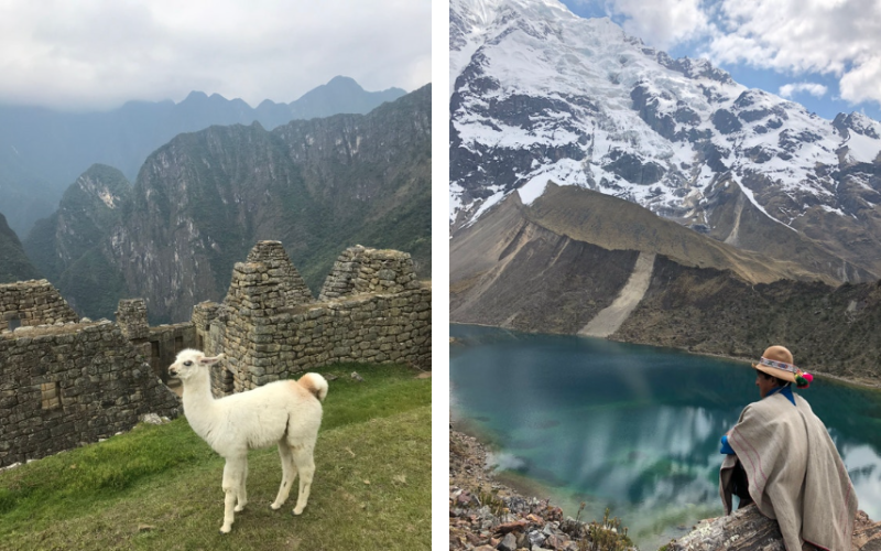
The Salkantay Trek
Photos by Sara Lieberman
- Location: Peru
- Distance: 50 miles
- Difficulty: Hard
We climbed through cloud forests where butterflies followed my feet. We slept in lodges where llamas grazed near the outdoor hot tub. We indulged in a traditional Pachamanca (cooked under the earth) barbecue after an eight-mile descent from a 15,000-foot pass. This, dear readers, is the Salkantay Trek, a slightly less crowded alternative to reaching Machu Picchu. (The wildly popular Inca Trail fills up quickly.)
After five days of trekking with Mountain Lodges of Peru, logging more than 50 miles—during which we were occasionally accompanied by a sandal-wearing, flute-playing shaman named Herman—our arrival at “the Sanctuary,” aka Machu Picchu, almost felt like an afterthought. Almost. The journey was as memorable as the destination. —Sara Lieberman
The W Trek

Photo by Paulius Dragunas/Unsplash
- Location: Chile
- Distance: 30–50 miles
- Difficulty Hard
El Torres del Paine is one of the most popular hikes in Patagonia for good reason. There are two multi-day trek options—the O and the W—that lead to the torres (towers), three sharp rock pillars that look ready to pop and deflate the sky, above a milky turquoise lake. Because the O circuit requires about eight days, my tight schedule only allowed me to hike the four-day W trek.
I went during the peak of summer, starting on Christmas (celebrated on December 24 in Chile), feasting on a festive dinner in a banquet-style Paine Grande lodge the first night. Some sections of the trail terrified me, with slanted, gravely paths on the edge of cliffs; some parts charmed me, with timber tent platforms tucked into the trees; and some areas left me dumbfounded, like when a petrified forest led to an electric-blue glacier. By the end, my legs were shaky—in a good way. I’m absolutely going back to do the O. —Danielle Hallock
North America
South Kaibab Trail to Phantom Ranch

Photos by Nina K. Hahn
- Location: Grand Canyon National Park, Arizona
- Distance: 7 miles one-way
- Difficulty: Hard
The shortest trail to the Colorado River winds down to the bottom of the biggest chasm on the continent in a quick and sudden descent: a steep 5,000-foot drop in elevation in only seven miles. Don’t rush it: Relish all those gobsmacking views from Ooh Aah Point to the Tip Off on a guided REI Adventures backpacking trip. You’ll learn about endemic plants and ancient pueblo ruins, how to make the best cold lemonade on the planet, and the ABCs of tent pitching—the last of which happens at Phantom Ranch, a legendary creekside oasis and the only lodging below the rim. —Nina K. Hahn
Coyote Gulch

Photo by Photo Volcano/Shutterstock
- Location: Grand Staircase–Escalante National Monument, Utah
- Distance: 2–13 miles
- Difficulty: Moderate
In this part of Utah, there aren’t really any signs to point tourists in the right direction. These trails don’t want to be found easily, concealing themselves for those willing to look. You need a reliable compass and some way-finding skills to cross the endless-seeming sand of the Grand Staircase–Escalante National Monument and locate the crack in the earth that leads down to a hidden paradise.
Once my family found the “Crack in the Wall” entrance to Coyote Gulch, I took off my backpack to drop down a hole and squeeze sideways through a tight rock corridor descending deeper and deeper into the earth. Then the narrow passageway opened up to a shockingly green valley, full of waterfalls and lush vegetation against red rock walls surrounding an icy blue river. Since the trail often merged with the river, we put on water shoes to wade through the cool stream, making our way to arch formations at the gulch’s end.
Many people camp overnight under the arches (with a backcountry permit), but we continued on, using our hands to climb freestyle up steeply slanted rock slabs to get out. Once we did, I almost got heat stroke trying to find the car in the middle of summer, but we eventually succeeded. It’s a story I will tell for the rest of my life. If you want to reward yourself after, spend the night at Ofland Escalante or Under Canvas Lake Powell–Grand Staircase. —D.H.
Superior Hiking Trail

Photo by Sam Wagner/Shutterstock
- Location: Along Lake Superior, Minnesota
- Distance: 310 miles
- Difficulty: Varying degrees
Lesser known than the Appalachian and Pacific Crest trails but no less impressive, this through-hike connects eight state parks in its 310-mile run from Duluth, Minnesota, to the Canadian border. The route is broken into 50 sections; you can hike many of them in a day or a weekend. It winds through deep gorges and old-growth maple forests, past thundering waterfalls, and along rocky cliffs overlooking Lake Superior. No reservations are needed to use the trail’s campsites. But for a more pampered experience, lock in a lovely lakeside log cabin at Bluefin Bay’s Temperance Landing in Schroeder. (Your aching bones will thank you when they’re soaking in a double-wide Jacuzzi.) —Ashlea Halpern
Lower Crystal Lake Trail

Photos by Nina K. Hahn
- Location: Breckenridge, Colorado
- Distance: 4.6 miles round-trip
- Difficulty: Moderate
At 9,600 feet, Breckenridge is one of the highest towns in Colorado, and this moderately challenging hike delivers on a powerful high-altitude ascent. Starting at 10,174 feet, trek through a spruce forest, creeks, and alpine meadows straight out of The Sound of Music to a shelf at 11,900 showcasing the sparkling oasis of Lower Crystal Lake. That’s just a teaser, given you can trek even higher to Upper Crystal Lake at 12,600 feet and jaunt over to the summit of a “13er,” the 13,640-foot Peak 10. Get grounded at Gravity Haus, primly positioned at the end of Breck’s historic Main Street and exactly the place to sign up for a guided hike to the heavens with Colorado Adventure Guides, a company located right inside the hotel. —N.K.H.
Seven Sacred Pools Trail (‘Ohe‘o Gulch)

Photo by Tom Tietz/Shutterstock
- Location: Maui, Hawai‘i
- Distance: 4.5 miles
- Difficulty: Moderate
Of the many hikes I’ve done around the world with my family, our trek through Haleakalā National Park to the Pools of ‘Ohe‘o, or “Seven Sacred Pools,” in eastern Maui is easily the most memorable. It’s only accessible via the Hana Highway—famous for its hairpin turns, 59 bridges, and waterfall-studded landscape. The hike, deep within a rainforest, involves moving through lush, ecodiverse woodland, crossing freshwater streams (no bridges, just rocks to grab onto for balance) into a bamboo forest humming with ‘apapane birds, and eventually ascending to a dramatic 400-foot waterfall. It began to rain as we reached Waimoku Falls. Within minutes we were up to our knees in mud. Our muckiness—it was a slippery descent—commanded a scrub-down in the Pacific. It was glorious. —Amy Tara Koch
Australia and New Zealand
wukalina Walk

Photo by Rob Burnett
- Location: Tasmania, Australia
- Distance: 20.5 miles
- Difficulty: Moderate to hard
Owned and operated by Tasmania’s Indigenous palawa community (the community traditionally only uses capital letters for people’s names), the four-day, three-night wukalina Walk is a unique way to explore the island’s rugged northeast coast and gain insight into Australia’s Aboriginal heritage. I planned my entire two-week trip to Tasmania in November around the experience.
My journey began with a hike to the peak of wukalina (aka Mount William). Six fellow travelers and I enjoyed a picnic lunch with views stretching from the Furneaux Islands in the north to the Bay of Fires in the south. Our guides were Hank, who had decades of touring experience, and Carleeta, a 19 year old from Cape Barren Island.
A few hours later, we tramped into Krakani Lumi, a secluded camp a few hundred feet from the shore. Eco-chalets were inspired by traditional palawa huts, with pitch-black walls and domed interiors. As the stars came out, we dined on gamy muttonbird and fresh scallops roasted over an open flame.
The next morning, we walked along the white-sand beach to shell middens where ancient clans came to feast. I helped Carleeta dive for sea snails in the frigid waters of the Bass Strait, which we boiled and snacked on while learning to throw spears and make shell jewelry.
During the next day’s 10-mile hike along blustery beaches dotted with lichen-covered boulders, we learned about Tasmania’s tragic colonial past. I spent the night under a plush duvet in the renovated lighthouse keeper’s cottage at Eddystone Point while wombats and wallabies nibbled the lawn outside.
Before a final goodbye back in Launceston, I spoke to Clyde Mansell, the community elder who spent more than 15 years setting up the wukalina walk. “The experience and scenery are just beautiful packaging,” he said. “The real purpose of the walk is to keep the community’s young people engaged with our culture and provide them with jobs in hospitality.” The walk had also allowed me to engage with the culture, and my time in Tasmania was all the richer for it. —Eric Rosen
Routeburn Track

Photos by Greg Redman and Laura Dannen Redman
- Location: Fiordland and Mount Aspiring National Parks, South Island, New Zealand
- Distance: 25 miles
- Difficulty: Moderate
After completing a three-day, 25-mile hike along the Routeburn Track in New Zealand’s majestic Fiordland and Mount Aspiring National Parks, my body tingled with accomplishment and my brain raced through the mental snapshots taken on our guided trek with Ultimate Hikes New Zealand. The Valley of the Trolls, where glacier-carved fiords turned from aquamarine to steely gray as the light shifted. A hot cup of Milo atop a hill covered in edelweiss and daisies. An alpine lake of polar plunge–worthiness beneath a glass-walled lodge where a hot fire and warm meal await. Our bright orange packs like a parade of tiny dots as we passed beneath freestanding boulders the size of giants. No wonder the South Island became a set for Middle-earth; no wonder they call these “Great Walks.” —L.D.R.
Valley of the Winds Walk

Photo by Maurizio De Mattei/Shutterstock
- Location: Uluru-Kata Tjuta National Park, Northern Territory, Australia
- Distance: 4.6 miles
- Difficulty: Moderate to hard
There are few destinations more iconic in Australia than Uluru, the massive sandstone rock in the Central Australian desert. For decades, it was known as Ayers Rock, a tourist attraction that visitors would try to summit despite pleas from the rock’s original custodians, the Anangu, to not climb it. Finally, in October 2019, park policy honored the Anangu’s request to treat Uluru as a sacred space and prohibit climbing—though you can still walk around it and explore the park with greater cultural context.
Several walks take you down the same path as the area’s Aboriginal ancestors—the base walk around Uluru is one of the easiest entry points—but I’d recommend the Valley of the Winds hike, a tougher and less-trafficked climb among the 36 dramatic Kata Tjuta domes.
The trailhead is a 30-mile drive from Uluru—just put “Kata Tjuta Valley of the Winds” into your location finder. From the car park, the 4.6-mile circuit is a mix of red dirt and loose rock. It can be steep in parts and the heat unforgiving. But you’re rewarded with two lookout points—Karu, about an hour in, and Karingana at the 2.5-hour mark—and views of this Mars-like stretch of Northern Territory. The Valley of the Winds is a culturally sensitive area; Anangu ask that you don’t post photos on social media. “According to Anangu culture,” per the park’s website, “these rock formations hold knowledge that should only be learned in person and on location by those with the cultural authority to do so. By respecting Anangu’s wishes, you are ensuring the continuation of Anangu cultural beliefs and the protection of their spirituality.” —L.D.R.
Europe
Faroe Islands

Photo by Kotenko Oleksandr/Shutterstock
- Location: Faroe Islands
- Distance: Varies
- Difficulty: Varies
With 18 islands to explore, the hiking in this rugged North Atlantic archipelago is spectacular. But to reach the wildest, windswept spots, you should tap the brains of insiders—people like Jóhannus Hansen of Reika Adventures, a Faroese native and international climbing instructor, and Tummas Rubeksen, a farmer near Tórshavn who runs the hiking outfit Heimdal Tours. When you’re all full up on the Tolkien-esque scenery, sit down to an intimate family meal with locals. The Faroese call this heimablídni, or home hospitality, and folks throughout the islands participate by opening their dining rooms to strangers. The spreads are as memorable as the sea cliffs, featuring anything from dry-salted whale blubber to strapping Faroese schnapps. —A.H.
The Hebridean Way

Photo by EyesTravelling/Shutterstock
- Location: Outer Hebrides, Scotland
- Distance: 165 miles
- Difficulty: Easy to moderate
The 165-mile Hebridean Way snakes through this windswept, 10-island archipelago off Scotland’s West Coast. The prettiest patch is in the middle, from Benbecula to North Uist, an easy to moderate 50-mile walk that’s ideal for a weeklong getaway. Amble through the rocky, peaty countryside as well as the fertile land known as machair, low-lying grassy plains that are studded with wildflowers through spring and summer. Practice your language skills, too: The locals here might speak English, but prefer to speak Scots Gaelic—madhainn mhath (má-tin va) is good morning. Stay in your own personal tree house en route. —Mark Ellwood
Reinebringen

Photo by rayints/Shutterstock
- Location: Lofoten, Norway
- Distance: 3 miles
- Difficulty: Moderate
In northern Norway’s legendary Lofoten Islands, where sheer mountains rise out of fjords to spectacular effect, it’s easy to embrace the friluftsliv (free air life), a Nordic ethos of maximizing an outdoor lifestyle. For one of the most accessible hikes (right off the main road through the archipelago), climb more than 1,500 stone steps up a mountainside to summit Reinebringen (1,469 feet). It’s less than a mile to the top, but from the lip of the cliff lies a nearly indescribable view. Let’s try anyway: Knife-edge peaks spike from a sheet of sapphire sea, with fishing villages jumbled like Lego blocks far below, crammed into nooks along the shoreline. When you’re back at sea level, reward yourself by driving four miles south to Holmen Lofoten in the fishing village of Sørvågen, where the seasonal migratory cod called skrei might be on the menu at the Kitchen on the Edge of the World. Sleep to the sound of lapping waves inside a rorbu—a seriously upgraded fisherman’s cabin that’ll have you convinced it was the Norwegians (not the Danes) who made a brand out of hygge. —Terry Ward
Andros Routes

Photo by Mazur Travel/Shutterstock
- Location: Greece
- Distance: 60 miles
- Difficulty: Varying degrees
The rocky islands that form the Cyclades cluster are ideal for hikers of all skill levels, but the well-established and -maintained paths on the island of Andros are a standout. Sixty miles of them quilt the 93,900-acre island, snaking between ancient villages, and are ideal for day hikes. Try the four-mile, one-way journey from the chora or the old town of Andros down at the waterfront, up into the interior—it’s largely cobbled, and coils through little mountaintop villages, with an easy detour to the Pythara waterfalls. —M.E.
Mount Prana, the Apuan Alps

Photo by PhotoFra/Shutterstock
- Location: Versilia, Italy
- Distance: 5 miles
- Difficulty: Moderate
The Apuan Alps, in an underrated corner of Tuscany, form a rocky ridge a short drive from the glorious beaches of the Versilia coast. There are countless day or half-day hikes dotted around them, mostly centered on the town of Camaiore. Head to Gabberi mountain for a 3.5-mile hike with spectacular views over the Mediterranean, or Mount Prana (the southernmost peak of the range) where you’ll climb through terraced fields and chestnut woods before you reach the 4,000-foot summit. The white caps you’ll spot aren’t snow; rather, they’re scars from the marble quarries here, including the source of Michelangelo’s David. —M.E.
Parenzana

Photo by Bailey Berg
- Location: Italy, Slovenia, and Croatia
- Distance: 76.5 miles, one-way
- Difficulty: Moderate
From 1902 to 1935, Parenzana was a railroad connecting the port towns of Trieste, Italy, and Poreč, Croatia, by way of Slovenia, shuttling both people and Istrian goods, like olive oil and wine, throughout the area. But after the train stopped running, the track was somewhat forgotten. That is, until the early aughts, when some Croatian hiking guides, including Vida Ungar and Daniel Lacko (who now work for Country Walkers, a hiking company that operates itineraries in two dozen countries), found out about it and vowed to see it turned into an opportunity for recreation. They worked with the government to get all 75-plus miles cleaned up and turned into a multi-use trail.
Some parts of the path hug the shore, passing marinas with brightly colored sailboats bobbing in the briny water. In other areas, the undulating path moves through valleys dappled with vineyards and thick forests on a path lined by wildflowers. Along the way, hikers and cyclists go through stone railroad tunnels, cross century-old viaducts spanning steep canyons and raging rivers, and navigate through medieval hilltop villages, filled with art stores and café-bars where truffles are part of most entrée’s DNA. —Bailey Berg
Asia
Kumano Kodo: Nakahechi Route

Photo by Peter Bohler
- Location: Japan
- Distance: 42 miles
- Difficulty: Moderate
“You’re going alone?” a friend asked me. I had been talking about a five-day trek on Japan’s Kumano Kodo, a 10th-century network of trails roughly 100 miles south of Kyoto that was named one of two 2004 UNESCO World Heritage spiritual pilgrimage sites. (The other is the Camino de Santiago in Spain.) My 42-mile route, dotted with more than 100 Shinto and Buddhist shrines, would traverse the secluded Kii peninsula through sleepy farm towns and forests of cedar, cypress, and bamboo, over mountain passes, across rivers, and past waterfalls. And yes, I was going alone. —Peggy Orenstein.
The Garhi hike

Photo by Himanshu Lakhwani
- Location: Palampur, Himachal Pradesh, India
- Distance: 8.7 miles round-trip
- Difficulty: Moderate
It’s early in the morning. Winter’s turning to spring. But the slopes of the Dhauladhar Mountains in the lower Himalayas are still blanketed by snow. Raj Mal, our shepherd-guide from Exsul Travel, leads us through mustard fields and pine forests. Past the tree line, the land is all stone and bramble. Geckos sun themselves on rocks while kite birds circle above watching for prey. Raj Mal has walked this route since childhood. His sheep-rearing community takes their flock every summer to graze on fresh grass up on the mountain. Our destination, the abandoned village of Garhi, at 8,000 feet above sea level, is but a pit stop on their annual journey. Along the way, we pause for a picnic breakfast and French press coffee. Raj Mal points out wild medicinal herbs and flowers foraged for food. When we reach the top, six hours later, the view is breathtaking. A galaxy of twinkling lights stretches below us, all the way from Dharamshala to Palampur, where we’d begun our journey. After an Indian dinner by the campfire, we turn in for the night, our beds made inside mud huts the shepherds use. It’s as authentic as it gets. —Prasad Ramamurthy
The Trans-Bhutan Trail

Photo by Marish sharma/Unsplash
- Location: Bhutan
- Distance: 250 miles
- Difficulty: Moderate to hard
After falling into disuse for 60 years, the Bhutanese government restored and reopened the Trans Bhutan Trail—which spans the entire country—in 2022. So I eagerly signed up for a weeklong trek in 2024. You can hike as much of the 250-mile path as you’d like, though I choose the most traversed (for Bhutan, anyway) section linking the capital of Thimpu with the famously photographed Tiger’s Nest temple hanging on the edge of a cliff. The hike is government-run, and a local guide dressed in red robes accompanies tourists the entire time, sometimes using a machete to maintain clearance along the trail.
My guide broke out herbal tea at the tops of 12,000-foot summits so my partner and I could linger over the views of forested mountains speckled with medieval architecture, since all buildings in the country are mandated to be built in the same traditional style from the 1600s. The guides arrange for guests to sleep in several lodge options along the way, including my favorite, the Soednam Zingkham Heritage Lodge, which serves special buckwheat momos, butter tea, and the national dish of spicy chili cheese in a wood dining room heated by a woodburning stove.
I highly recommend ending the trek with a hot stone bath, which you’re encouraged to soak in for three 20-minute intervals—or the entire hour, if you can stand it. After sweating through my session, I felt deep muscle recovery and, fittingly for the land of the dragon, hot enough to breathe fire myself. —D.H.
Tiger Leaping Gorge

Photo by Shutterstock
- Location: China
- Distance: 18 miles
- Difficulty: Moderate to hard
I had no intention of hiking Tiger Leaping Gorge. But thanks to a chance meeting on a train and the hubris of youth, I spent two days hiking 18 strenuous miles over mountains, through terraced rice fields, and around waterfalls with a couple of guys I’d just met. And it was my favorite memory of more than a year spent living in China.
Tiger Leaping Gorge is named after a folktale about a tiger who escaped a hunter by jumping over the river. The dirt track isn’t for the faint-hearted or the weak-kneed—the trail gains roughly 6,500 feet of elevation within the first few miles. But the views from the upper section of the path are dazzling. Above you are the snowcapped Jade Dragon and Haba Mountains, and, far, far below, the turbulent Jinsha River, a major tributary of the Yangtze, rages through the gorge. As you hike, you’ll pass through small villages home to Naxi people (an ethnic group in China’s Yunnan and Sichuan provinces) with simple guesthouses and eateries. —B.B.
Africa
The Whale Trail

Photo by A. Emson/Shutterstock
- Location: De Hoop Nature Reserve, South Africa
- Distance: 36 miles
- Difficulty: Easy to moderate
Western Cape’s De Hoop, a coastal nature reserve, is an easily planned weekend getaway and, thanks to the addition of new hotels in the area, a must-add to any Cape Town trip. Within the 84-acre wilderness area, travelers can go on both guided and self-guided safaris, laze on the pearly beaches, and hike a stretch of the Whale Trail, a fynbos-carpeted hiking route that winds along the coast for 36 miles. Although the Whale Trail is a registered hike (which you have to sign up for in advance), visitors to De Hoop can still follow the trail’s coastal walkways. Morukuru Beach Lodge and Lekkerwater offer walks with nature guides who help point out local plants like king proteas. If you want to see animals, drive around the reserve and look for antelope, or head down to the beach at low tide to spot marine life. —Mary Holland
This article originally appeared online in 2021; it was most recently updated on May 19, 2026, to include current information.


